.svg@webp)
Pixpro Waypoints v2 - Orbitals and Height Offset for DJI Drones
 Lukas
Zmejevskis
Lukas
Zmejevskis

Pixpro Waypoints is a service for consumer DJI drone users that provides consistent and automated flying for aerial photogrammetry purposes. For now, we had the essential single grid flight only, which is the bread and butter for making orthophoto images and terrain scans. Now, we have added orbital flights and some additional small new features to the service. Let us go over the updates and look at some examples.
New Features
Here is a small list of updates we made to the service:
• Orbital flights. We added a circular flight type that does not use tracking or even POI functionality for maximum flexibility; more on that later.
• Single grid height offset. For precise overlap control when, you cannot take off at the specific altitude of your subject.
• The new UI replaced the default buttons with ours, which is neater and more touchscreen-friendly.
• Area and flight path length information. Additional information about your generated flight adds some utility.
Despite the new features, overal workflow with Pixpro Waypoints remains the same, as described in a previous blog post:
Pixpro Waypoints - Automated Photogrammetry Flights for Latest DJI Drones
Pixpro Orbitals - Just Better
With the latest DJI drones, we are used to doing orbital scans using the circular hyperlapse feature. It works fine when you get the hang of it, but our solution has many advantages and only a single con. The single disadvantage of using Pixpro waypoints is that you need to preplan the flight or use another device in the field to plan one if you are using an Android phone that is not rooted. Yes, this has a lot of conditions, but admittedly, it is a popular workflow for many.
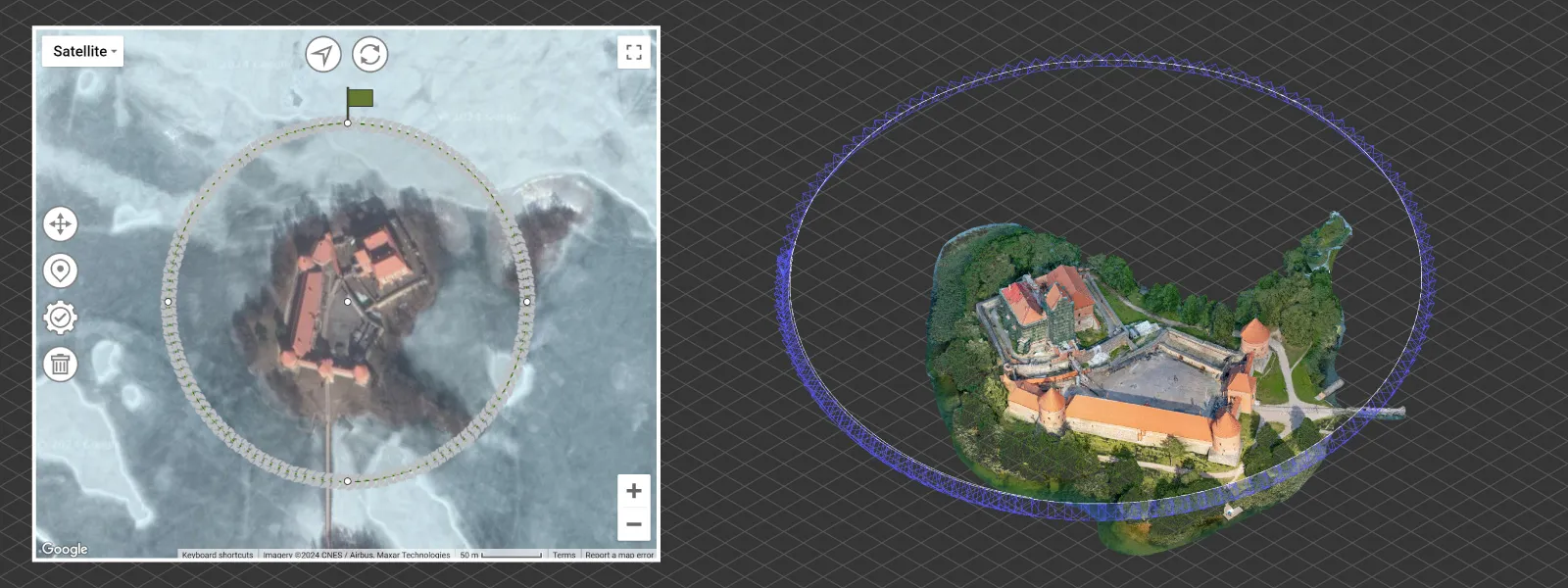 You get the pros only if you use any Apple device, have no issues preplanning the flight, or bring a laptop (tablet or another phone for your Android device) to the field. Hyperlapse tracking is much less reliable in doing perfect circles around a fixed center, as the tracking is visual. Often, you can select a wall of a building, which is, of course, not in the center of it, that either makes the orbit an oval with real-time adjustments or just offsets to one side. Hyperlapse modes also force you to wait until a video is created, which we do not need, and most importantly, you need not worry about the speed of the drone or the amount of photos you take, as this is calculated for you by our service. Every orbit will have the perfect number of images made at the interval you chose, and there will be no redundant overlap as the flight stops when a circle is completed.
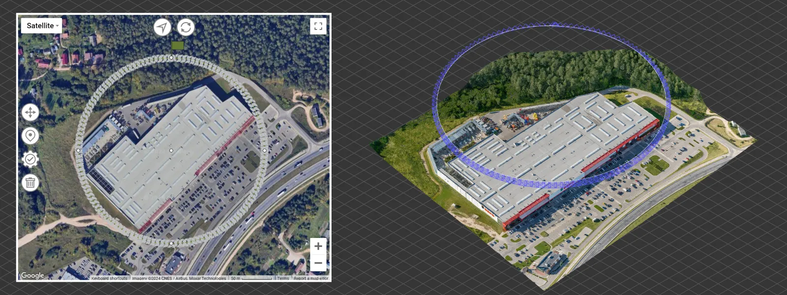 Our orbitals are based on orientation and not POI tracking, which means that the drone's gimbal is unlocked, and you can point it wherever you want and make real-time adjustments. This is why our orbital workflow requires you to point the camera manually, according to the subject and your needs. This is the most reliable way of ensuring perfect orbital coverage. So, there is no input for the subject's height in the planning phase.
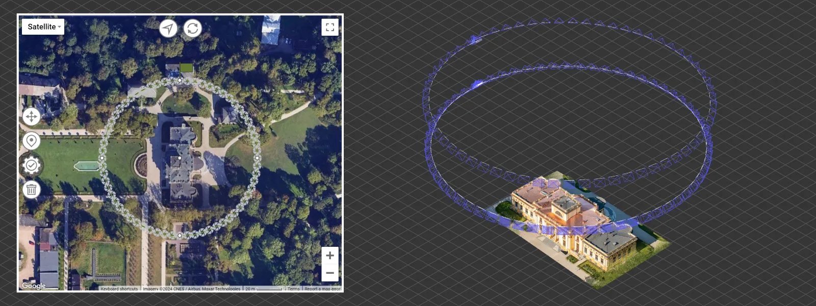 Lastly, our approach allows tuning the plan in the DJI fly app. Once you replace an existing file with our waypoints file, as is the regular workflow, and open the app to inspect it, you can adjust the altitude in the waypoints editing interface without breaking the plan. You can also choose different gimbal settings. Do not edit the orientation setting; the drone will still point to the center when you fly. The examples you see between paragraphs are made with the DJI Mavic 3 Pro and Pixpro photogrammetry software using our waypoints service.
Flight Heights Offset
We added the offset option to improve the usability of single grids and other upcoming grid flights. This option will help maintain correct overlap if you take off lower or higher than the subject you wish to scan because the flight height is calculated from the takeoff location. The most common example is a roof scan of a building. If we scan a sizable commercial roof like we did in our previous post and we take off from the ground, that will reduce the effective overlap at the roof, which is higher.
Commercial Roof Scan and Inspection
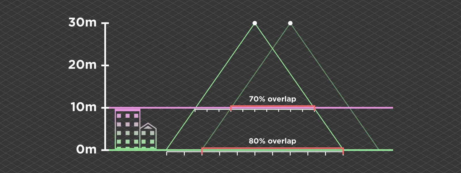 If we fly at 100 meters and scan a building that is 30 meters tall without the offset, the effective overlap is reduced by 30 percent. We encountered many cases where the building height was not considered, rendering a photoset useless. In the case of negative offset, when scanning a pit, for example, a larger overlap than expected is less of an issue. However, still, we can use offset to reduce the number of photos we take to save space and time.
Combining Orbitals and Grids
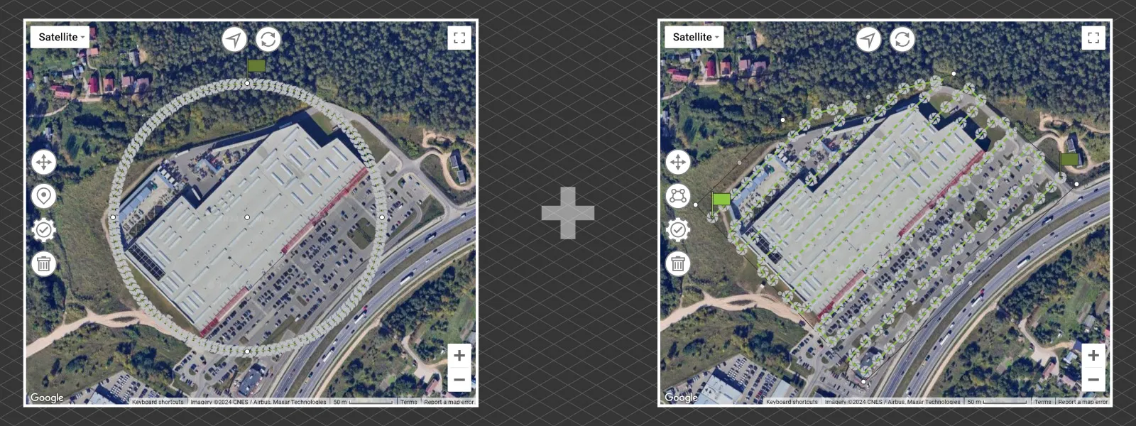 Having two types of flights allows us to combine both. As we discussed in earlier blog posts, combining different flights, especially orbitals and grids, will provide superior results than using only one while being more efficient than some complicated multi-oriented plan for those who do not need extreme detail. You can create and execute as many waypoint flights as you like or your drone battery allows. Remember to create as many placeholder plans as you need.
Conclusion
Pixpro Waypoints service is available for DJI Mavic 3, DJI Mini 4, and DJI Air 3 series drones and any upcoming drones that will support waypoints. In the future, we will expand with more options and types of flights. With a bit of ingenuity from our side, we can make these drones just as capable as enterprise ones for photogrammetry, and you can take advantage of the service right now if you have an active Pixpro license or trial.
Photographer - Drone Pilot - Photogrammetrist. Years of experience in gathering data for photogrammetry projects, client support and consultations, software testing, and working with development and marketing teams. Feel free to contact me via Pixpro Discord or email (l.zmejevskis@pix-pro.com) if you have any questions about our blog.
Related Blog Posts
Our Related Posts
All of our tools and technologies are designed, modified and updated keeping your needs in mind
Pixpro version 1.7.9 and our 2025 Goals and Expectations
In this blog post, we have a small update to our Pixpro photogrammetry software and a bit of speculation and planning for the upcoming orbit around our G-type main sequence star.

Pixpro Cloud Processing - Layer Settings Explained
In the latest version of Pixpro, we have more cloud processing options. We can choose which layers to process and some settings for them. I will go through the entire cloud computing workflow in this article, including layer selection and settings.
DJI Mavic 3 Pro vs. DJI Air 3S - Ultimate Flying Camera
In this article, I compare two of the best drones on the market. The Air 3S is the newer mid-range drone that comes with the latest DJI tech and some new stuff, while the Mavic 3 Pro is a tried-and-tested flagship model at the tail end of its manufacturing run.
Ready to get started with your project?
You can choose from our three different plans or ask for a custom solution where you can process as many photos as you like!
Free 14-day trial. Cancel any time.