.svg@webp)
Slope Monitoring and Landslide Prevention
| Industry | Road Construction, Mining, Environmental Protection |
| Objective | Slope analysis and landslide prevention |
| Drone | DJI Phantom 4 pro |
| Flight Data | Camera angulation: Various: 90o top down Grid: Manual Horizontal Height: 100 m Duration: 17 min |
| Dataset Size | 190 images |
| Data Processing | 27 min using medium software settings |
| Hardware | Intel i7 8700, 16 GB of RAM, dual Radeon rx580, SSD drive |
Challenge: landslide prevention
Nowadays, a construction industry is a part of our everyday life. The buildings, roads, ponds and reservoirs are designed and constructed daily. These are complex structures, requiring special attention to detail including future landslide prevention.
One of the key points for every construction project are the ground works, which provide the foundation for the structure. If the structure isn’t stable, it can cause a number of incidents resulting in huge financial loses or even worse – cause bodily harm.
The main problems that cause the landslides are heterogeneous soil and water flow impact on the particular site. To measure these processes, the computer technologies with corresponding software are used. The tech innovations have replaced drawings and calculations using numerous formulae, and the computer modelling significantly accelerated the model reconstruction process allowing faster analysis of the slope processes.
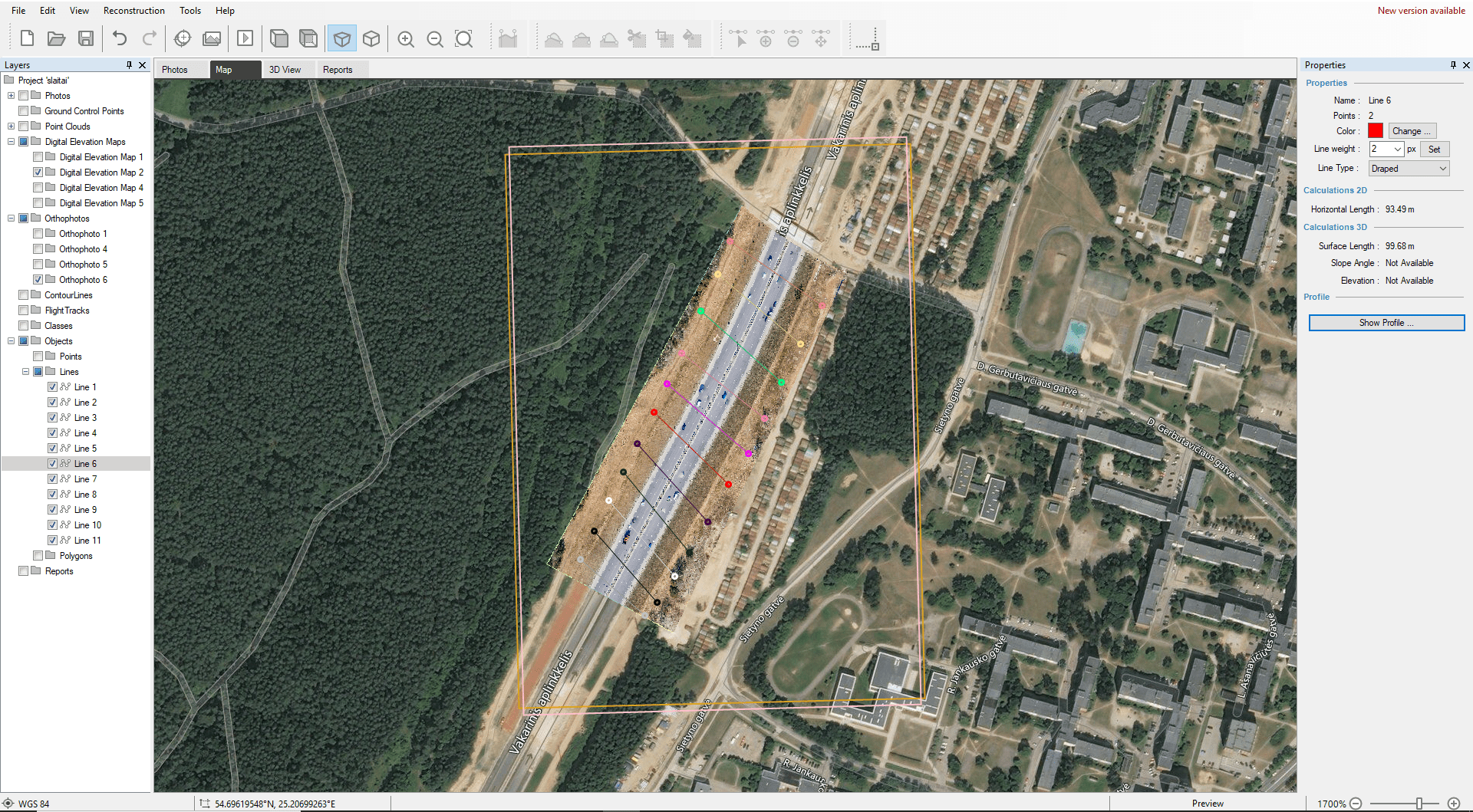
Data gathering for landslide prevention
This section of the road, with its slope, stretches across 500 meters and already had several deformations on its slopes (landslides). DJI Phantom 4 Pro drone, flown at an altitude of 100 meters took 190 photos using a 20-megapixel, 1-inch imaging sensor camera. Total flight time took 27 minutes.
Data processing for landslide prevention
The Pixpro software reconstructed the 500 meters road segment in 27 minutes. The full analysis of the object was performed on the DEM layer which provides extremely accurate and only slightly averaged data.
Data analysis
High quality Orthophoto enables seeing the 3D bird’s eye view and already provides insight on the slopes surface type and state. In this case it is possible to observe grassy, newly made embankments.
The Orthophotographic shading gives the user an opportunity to immediately notice the beginning of shallow slope failure in two particular areas which is difficult to spot with the regular DEM. These examples are the obvious warning signs that the slope might be unstable and prone to shallow, rainfall or vibration included failures.
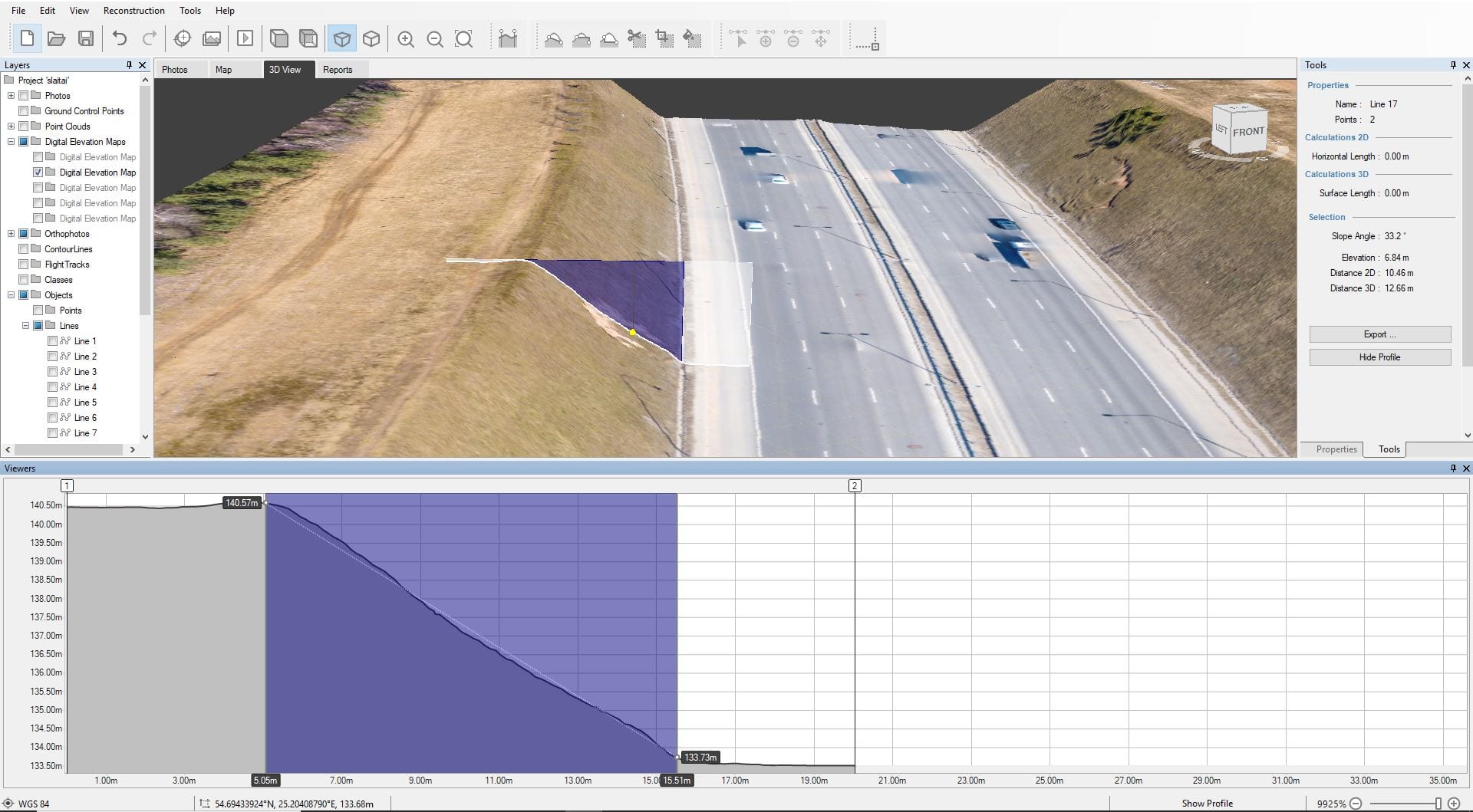
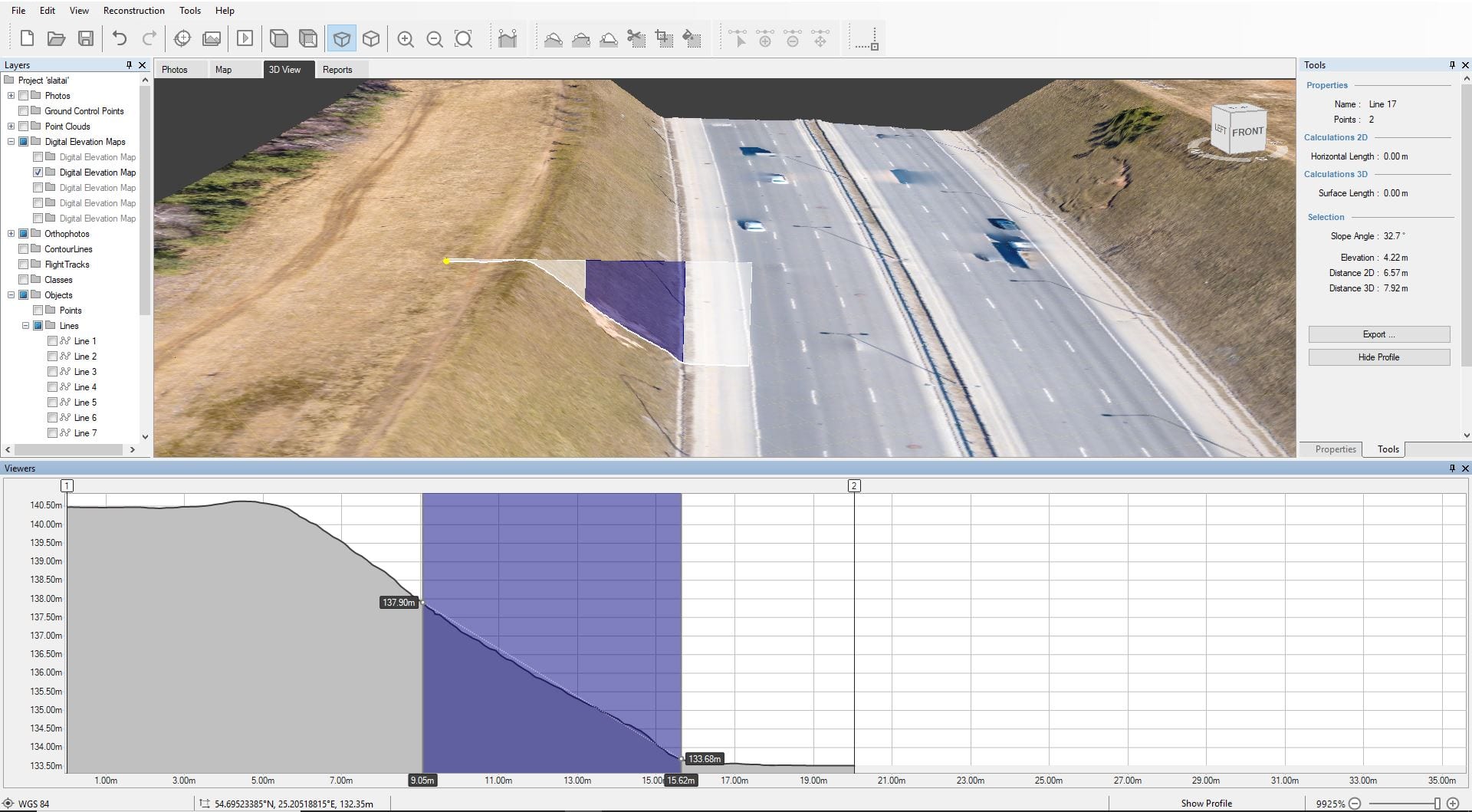
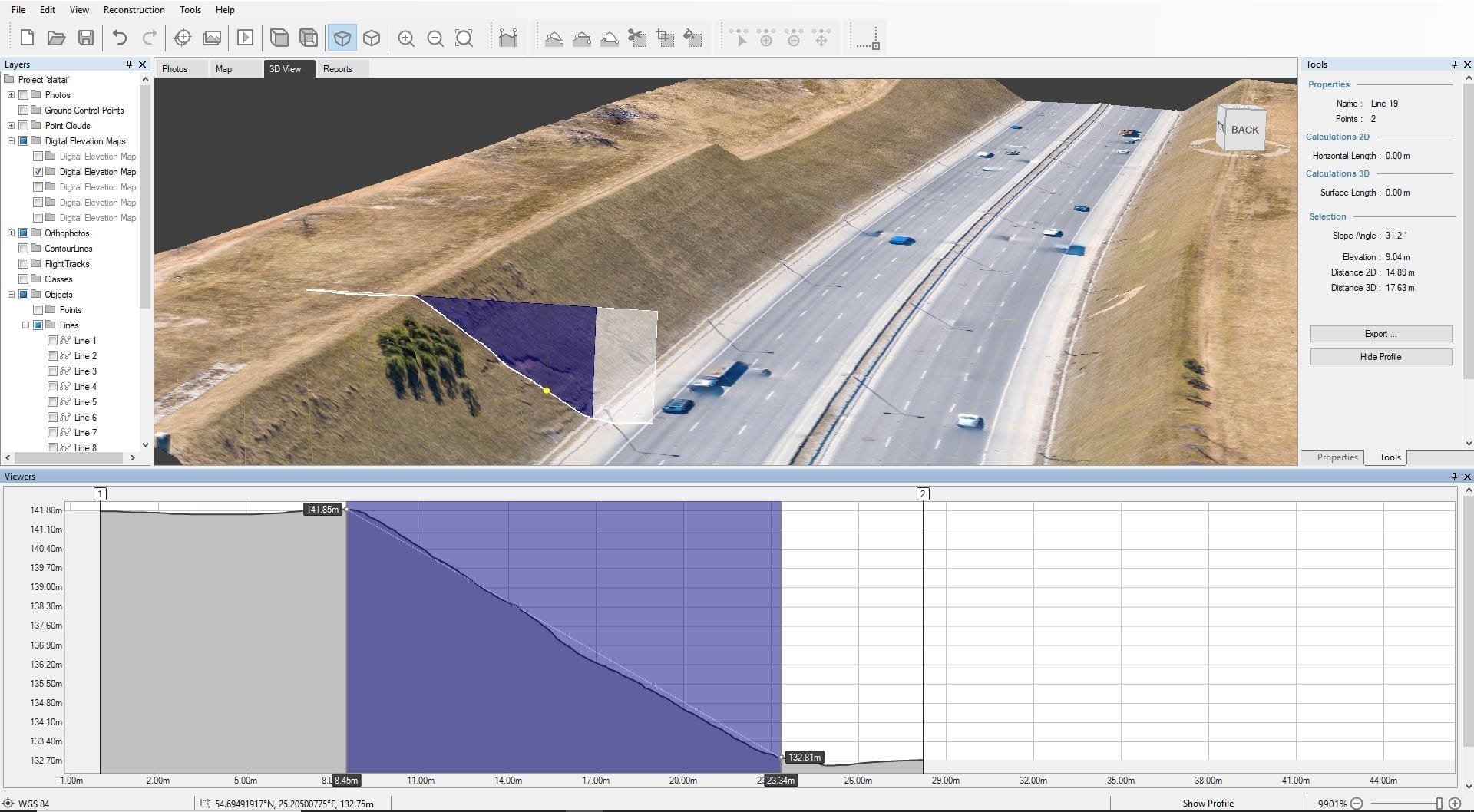
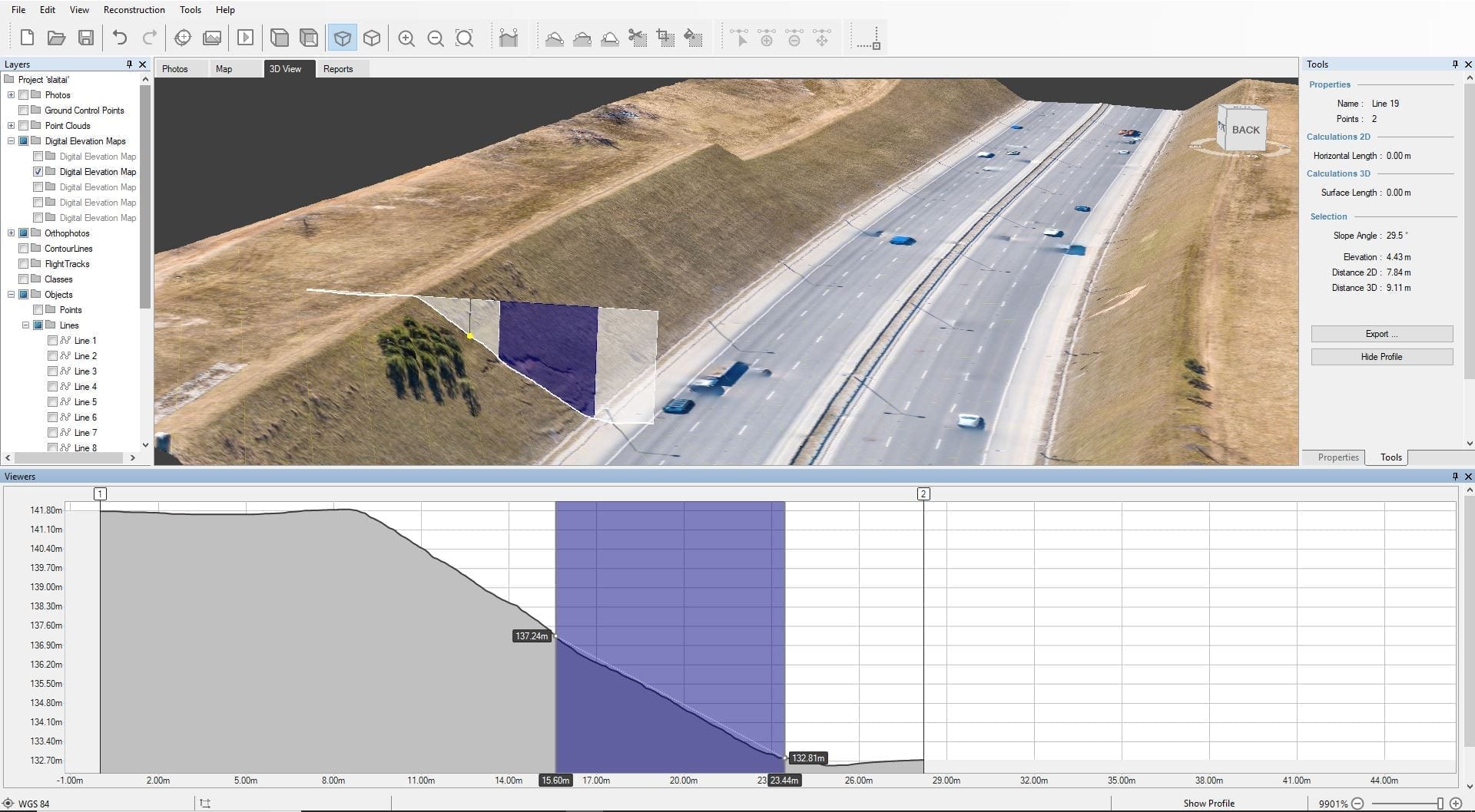
The pictures below show, how the use of the profile function helps to estimate the height at which slope starts to erode. Comparing the slope and the landslides heights in 2 different places, we can see that the landslides have emerged almost at the same level despite the difference in slopes’ height, i.e. at the elevation level of 4,2-4,4 meters. The inclination of the slope angles is almost the same (31-33 degrees) at both points.
| Height (m) | Slope Angle (o) | |
| Slope 1 | 6.84 | 33.2 |
| Landslip 1 | 4.22 | 32.4 |
| Slope 2 | 9.04 | 31.2 |
| Landslip 2 | 4.43 | 29.5 |
Based on these findings, you can conclude that slopes with these slant measurements, should not be formed higher than 4 m. Water pathways as well as a variety of slope stabilization techniques are used for roadbeds with especially steep and high slopes that get constantly effected by water.
Photogrammetry and drones for landslide prevention – time and lifesaver
It’s an especially accurate, time saving and most importantly – safe solution.
The detailed 500-meter long road segment model was created in approximately 45 minutes (excluding the logistics time to the location).
Using a drone, you do not need to send surveyors on a busy road, thus increasing their safety. It also eliminates the need for road closures or other traffic disruptions, thus not inconveniencing the drivers.
With just a few simple, mouse clicks you receive the valuable information about the height, slant, build and the height at which erosion first occurs, on the slope.
The collected and processed information has an enduring value. The road slopes must be monitored continuously to compare the course of their change. Only the timely monitoring and due measures can prevent from possible disasters.
Susiję tinklaraščio įrašai
Mūsų susiję įrašai
Visi mūsų įrankiai ir technologijos yra sukurti, modifikuoti ir atnaujinami atsižvelgiant į jūsų poreikius
Pasiruošę pradėti savo projektą?
Galite rinktis iš trijų skirtingų planų arba teirautis individualaus sprendimo, kuriuo galėsite Jums reikalingą nuotraukų kiekį!
Nemokamas 14 dienų bandomasis laikotarpis. Galite atsisakyti bet kada.