.svg@webp)
Most Asked Questions - Pixpro Waypoints
 Lukas
Zmejevskis
Lukas
Zmejevskis
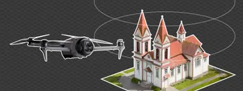
We have been receiving a lot of questions about our waypoint service. Pixpro Waypoints allow users to use the latest DJI drones for automated photogrammetry scans. We currently offer automated single grids and orbitals, and soon, there will be a third option. Now, we are dedicating an article to the most frequently asked questions about this service as it is today. We chose the top 11 most asked ones ever since our service launched.
1. How to use Pixpro Waypoints?
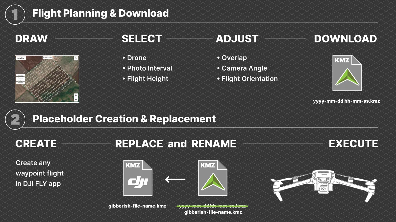
Pixpro waypoints workflow consists of these major steps:
• Plan a flight using our service, which can be found here: Pixpro Waypoints
• Download and save the plan to your computer or mobile device.
• Connect your drone to your remote controller, launch the DJI Fly app, and create a placeholder waypoint plan or plan. (placeholder plan can be anything, anywhere)
• Connect your remote controller to your device using the downloaded plans.
• Replace the placeholder plans with ours.
• Connect your drone back and execute the planned flights.
This is a high-level overview of how the workflow is executed. Before you start using the service, you will need to read our initial article about the service to get all of the details here:
Pixpro Waypoints - Automated Photogrammetry Flights for Newest DJI Drones
 2. What drones do Pixpro Waypoints support?
Pixpro Waypoints are compatible with the latest DJI drones that support waypoints: the DJI Mavic 3, DJI Mavic 3 Classic, DJI Mavic 3 Pro, and DJI Mavic 3 Cine versions, as well as the DJI Air 3 and DJI Mini 4 Pro.
3. Does it work with all remote control options?
Yes, DJI RC, DJI RC2, DJI RC Pro, DJI RCN1, and DJI RCN2 with Android and iOS devices will work with different workflows.
4. Why do I need to create a plan before uploading a new one?
Pixpro waypoint service is an unofficial workaround. While it is still a powerful tool, it requires a bit of "hacking." We must create an existing waypoint flight because the DJI Fly app will not read just any file. We make a placeholder file with a unique, for it only to be replaced by ours while giving it the same name, and then the app can read a flight path that we created. This is the only way.
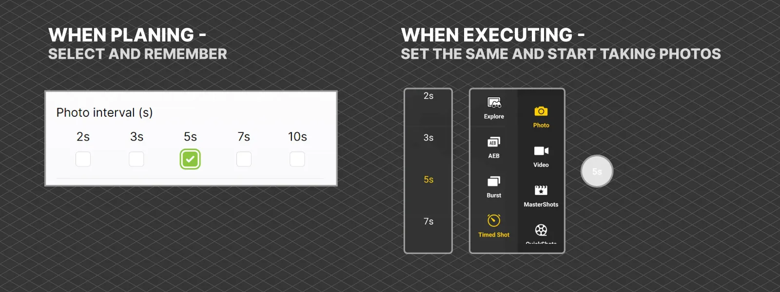
5. Why does the drone not take photos automatically?
When creating the waypoint plan, we cannot choose the capture mode and its settings. We provide a flight path, flight speed, and flight altitude. You need to go to time shot mode, choose the interval you decided during the planning phase, and trigger the shooting yourself when the drone reaches the first waypoint of the plan. You also need to stop the photo capture when the drone finishes the flight.
 6. Where do I put the file from the Pixpro Waypoints service?
If you are using an Android device, which includes the remote controllers with screens (all of them are Android-based), the directory is always the same: Internal shared storage\Android\data\dji.go.v5\files\waypoint
For Apple iOS devices, the directory is as follows: On My (Device name)/Files/DJI Fly/Wayline missions/
If you have not created a waypoint flight as per instructions, these directories may be empty or may not even exist before you do.
6. Why can I not use a single phone to plan, download, and input the file?
If you use an Apple iOS device, you can. If you use a non-rooted Android device, you can not because the device does not have the permissions to edit its own system files. DJI made it so that these waypoint files live in the system directory. This is an entirely arbitrary limitation by DJI and Android systems, with no real reason besides making one's life harder.
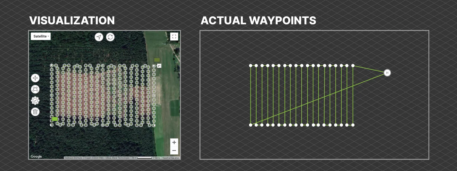
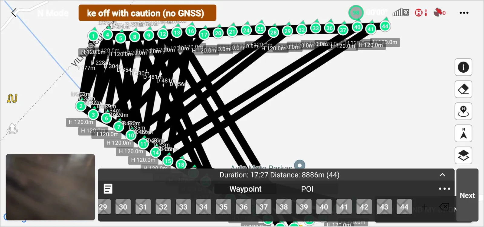
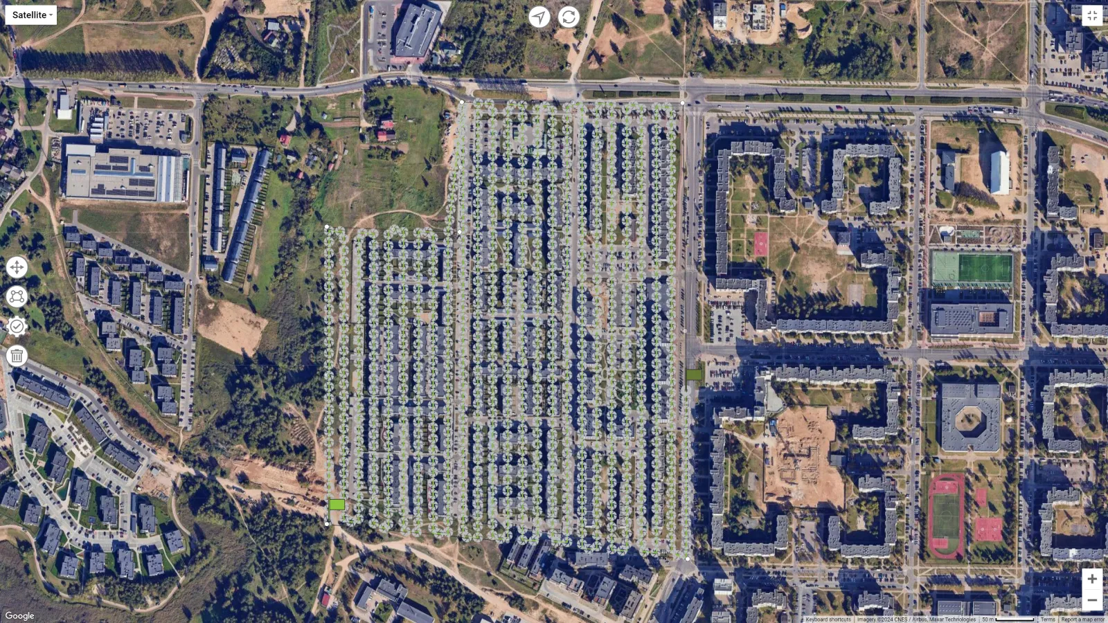
7. Do the depicted photo positions in the service mean the photos will be taken in those places?
No, it does not. These icons are just for visualization purposes. As you know by now, you have to trigger the photo capture yourself; the waypoint file does not contain any information on data capture. So, the icons on the map represent the overall density and the pattern of photos, but not exact locations.
 8. How do I do multi-battery scans with a waypoint flight?
You can end a waypoint flight at any time and resume it from any waypoint you choose. When the battery is about to run out, end the flight there and remember the last waypoint number the drone passed. The following waypoint number can be seen on the map and in the progress bar in the app during the flight execution.
We have a detailed article explaining the same workflow here:
Multi-battery Scans with Pixpro Waypoints
An alternative method is to plan waypoint flights in parts using flight time estimation. For that, you must know how long a battery lasts on your drone in the particular conditions you will fly in. This requires quite a bit of experience.
9. Why does the waypoint preview/thumbnail sometimes look scrambled or old?
This is a bug related to the nature of our workaround. These bugs are purely visual and do not result in different flights or drone behavior. Even if you see weird lines and not a perfect grid flight, look at the waypoint numbers. The drone will still fly sequentially, as you programmed it, using our service. You can still safely execute the flight, and even if the drone goes off course, any waypoint flight can be aborted at any time.
 10. How much does it cost to use Pixpro waypoints?
The service is available to all Pixpro subscribers and free trial users. This means that you can access the service for as little as 5 euros per month.
Bonus Question: What are the best camera settings when capturing with Pixpro Waypoints?
We recommend shooting in shutter priority - S mode and choosing a reasonably fast shutter speed, such as 1/400 of a second or even faster. Other settings can be left on auto. If you know how to process raw and want to maximize image quality, shoot in raw format. If you shoot a jpeg, always shoot a full resolution and uncropped 4:3 aspect ratio. 16:9 photos will not work.
Conclusion
If you have been a thorough reader of our blog, we thank you, but there was no new information here. We wanted to consolidate everything we have written about our waypoint service into a short list of questions and answers. If you follow the links we provided in the answers, you will find real-world use cases with examples and more in-depth looks. If you have questions of your own, join our Discord server or write us an email. Most of these questions were from these sources.
Photographer - Drone Pilot - Photogrammetrist. Years of experience in gathering data for photogrammetry projects, client support and consultations, software testing, and working with development and marketing teams. Feel free to contact me via Pixpro Discord or email (l.zmejevskis@pix-pro.com) if you have any questions about our blog.
Related Blog Posts
Our Related Posts
All of our tools and technologies are designed, modified and updated keeping your needs in mind
DJI Mini 5 Pro For Photogrammetry – Aerial Scanning With Pixpro Waypoints
DJI Mini 5 Pro is a 250-gram flying camera equipped with a 1-inch type sensor. Nine years ago, the Phantom 4 Pro was released as the first consumer drone to feature the same sensor format.
Pixpro Waypoints – Frequently Asked Questions Part 2
Pixpro Waypoints service is a workaround solution providing automated photogrammetry flights for the latest DJI drones. The service came about when DJI officially discontinued SDK support — and therefore third-party app development — for consumer-grade drones.
DJI Mavic 4 Pro Photogrammetry – Pixpro Waypoints
DJI Mavic 4 Pro is the flagship foldable consumer drone from DJI. It will become a workhorse for many creators in the next few years, including some of us in photogrammetry.
Ready to get started with your project?
You can choose from our three different plans or ask for a custom solution where you can process as many photos as you like!
Free 14-day trial. Cancel any time.